Chloride Canyon
We left the campground in Chloride NM about 10am, driving the Chevy TrailBlazer 4X4 with no idea what to expect!
What a journey! This is a single lane dirt road that crosses Chloride Creek about 40 times before you get to the top! We rode over so many rocks! You gotta do this road with 4 wheel drive, a high road clearance, and a brave heart! There are no high cliffs or big roadside drops to make you faint hearted, just the sound of rocks scraping along the bottom of your vehicle if it isn't high clearance enough!
You are gonna see lots of the windshield wipers and radio antennae in the pictures. Let me repeat... this was a very bumpy road! It was hard to get a good image without the wipers or antennae in the way!
As I said, it was also very narrow! I let Chuck drive this road... and glad that I did!
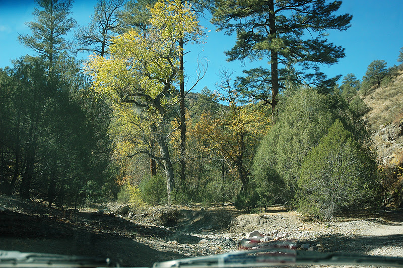
The yellow trees you see are cottonwood trees! They are turning colors all over New Mexico now!
Even the rock faces are colorful, these were sorta blue with red rusty colors!
Here you can see how the road tilts down to the left! There were so many tilted places but they all came out blurry because of the bumpy road! I only got one good one out of about 10 photos I took! Sometimes I felt like we might be nearly tipping over!
There were lots of nice rock formations to gawk at along the way!
Some of the rock formations were pretty darned close to the road!
Once and a while, the road would level out and widen a bit...
only to start another narrow, twisty turny road....
Higher up, most of the trees were bare...
but dodging roads around big rock walls kept Chuck's attention!
We even saw some petroglyphs near the road!
I wasn't sure if they were real or just faked by bored hunters! Linda, from Chloride says they are real and that there is a cave nearby that has more petroglyphs inside, we will try to check those out next time!
We were surprised to see cattle and cattle holding pens so far into the canyon!
At on Chloride Creek crossing, we actually had to go through water... about 3 inches deep! haha! But there must be a seeping spring nearby because there certainly hasn't been any rain in weeks!
Yep! That's the road ahead! So many rocks, it was hard to tell the creek bed from the road... and narrow too!
And then we meet a big white truck! No place to pass so what to we do? We back up, back into the creek at a lopsided angle and the other driver gets about 1/2 way past us and he's all lopsided too... and tell us to pull ahead. That way he gets past us and we were both in the clear! We were really lucky, we only met 2 trucks on this trip!
The cottonwood trees are really so pretty on the dirt roads!
The rocks just seem to keep jumping out at us!
Another dry creek crossing!
We even saw a very old log cabin/shack on the way!
Chloride Canyon became the adventure for a lot of prospectors in the late 1800's and early 1900's. Mr. Harry Pye discovered silver there and the town of Chloride was born! Of course, Harry Pye didn't get to spend much of his earnings from the silver as the Apaches ended his life and his prospecting!
We hope you enjoyed this journey up Chloride with us! Next adventure will probably be back in San Antonio NM at the Bosque del Apache wildlife refuge with the Festival of the Cranes... when the sandhill cranes return by the hundreds each winter!
We hope that you take the time to visit Chloride and Chloride Canyon the next time you are in NM!
http://www.pioneerstoremuseum.com/
Happy Trails from Geri, Chuck and our hound herd:
Scotty, DoogieBowser and Radar!


Thank you for this post and all the wonderful pictures!! We're heading to Chloride on Thursday to camp for a few days. This post was VERY helpful!!!
ReplyDeleteI use to deer hunt Chloride Creek with my Dad back in the late 60's to early 70's. We camped at a location that was as far up into the Canyon as we could take our truck and cab-over truck camper. We walked the rest of the way to our hunting spot.
ReplyDeleteWe did not know what we were seeing at the time, but later discovered that we had located an Army troop's graves that had been caught in the Canyon and killed by the Apache (we discovered what they were when someone who knew what they were looking at did some research to verify that they were in fact graves and who's graves they were). There were several rows of graves, rocks stacked on top of them about waist high (I was 14/15 when we located them). The guy that figured out what they were, wrote an article about them, and published it in a mag or newspaper. He figured that the rows, spaced several yards apart, were whites, then blacks, then Native Americans....whites in one row, blacks in another, then Native Americans.
That does not make sense to me because Blacks did not serve with whites in the Army. There may have been some Indian Scouts with them, however. I suspect the rows were Officer, Non commissioned Officer, then enlisted soldiers, then Indian Scouts.
At any rate, I have been dreaming about a trip back there with my wife just to camp and see the area again. At the time the article was written, there was talk about making the area a historical marker. I don't know if that ever happened. I live in Oklahoma now and I sure do miss New Mexico.
Do you have gps coordinates? I'll be there in August. jerry.housejr@gmail.com
ReplyDeleteNo gps at the time. Wife and are planning a trip in sept 2018. I will get gps coordinates and post them here if I can remeber to do so and if i can find this site again.
ReplyDeleteHow far in the road are the fabulous pictographs (those displayed in the photo are pictographs, which are painted , not petroglyphs which are pecked into the rock), cabin, cave, graves? I'm wondering about mountain biking in since the road is so narrow and rough.
ReplyDelete